GIS >Settings > General (select from Main Menu)
Set general GIS settings.
This function opens the GIS General Settings box in which the following options can be set at the tick boxes:
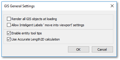
•Render all GIS objects at loading: This option is useful especially for large projects to render all objects at the beginning when the project is loaded. Hereby the user will not further be interrupted during the working session, by waiting for object rendering to be completed when zooming in/out or panning.
•Allow Intelligent Labels 'move into viewport' settings: When this option is ticked, Intelligent Labels may extend into viewport areas.
•Enable entity tool tips: When ticked, tool tips will be displayed when hovering with the mouse pointer over entities.
•Use Accurate Length 2D calculation: Normally the Great Circle formula is used to calculate meter lengths from latitude and longitude coordinates (and is 0.3% inaccurate). When, however, the Use Accurate Length 2D calculation box is ticked, then the more accurate Vincenty algorithm and the WGS84 ellipsoid of the earth are used for the length calculations. This method is more accurate (within 0.5 mm) but requires more calculation time. Note, the Use Accurate Length 2D calculation option is only applicable to the following:
oThe data layers currently viewed have underlying coordinates stored in lat/long (i.e. for layers, with underlying coordinates stored in projected units, this option is not applicable to);
oand the Length2D/Length3D fields are displayed in the grid table or a measuring tool is applied.