A Wadiso model can be built by importing GIS shapefiles of a water network (or part of the network) from a GIS model. Hereby not only the geometry of the Wadiso network model can be created, but also physical data of the network (contained in the GIS database fields) can be imported into the model. The Import from GIS function, accessible via Manage Models > Merge into Model > Import from GIS, opens the following Import GIS to Model box in which the following can be set for the importing process:
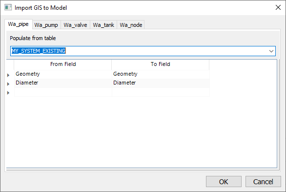
•Populate from table: Scroll to the relevant data frame, viz. Import into table wa_pipe, Import into table wa_pump, etc. depending on what type of entities you want to import. Select from the relevant drop-down list the source database table (of the GIS layer) to import. The above screen-shot shows an example of a SYSTEM_EXISTING GIS layer which was selected for the importing of pipes into the wa_pipe layer of the Wadiso model. The Import tick box will by default be ticked. You can always revisit an Import into... frame and simply untick the Import tick box if the specific data type should not be imported anymore.
•From/To Field: Check or edit the field mapping between From Field and To Field (matching field names will be listed automatically, e.g. the Diameter field as shown in above screen-shot). The From Field values of the GIS layer table will be transferred to (i.e. imported into) the To Field of the Wadiso model. Note that the function also automatically maps the internal geometric fields such as Geometry, Length2D, Length3D, VertexCount, and PartCount (you can confirm this by scrolling to the top, as well as to the bottom of From/To Field list).
•Click the Import button to start the importing process.
•Note, the above-described Import from GIS function will automatically build model topology when finished with importing i.e. Pipes and Nodes will get assigned numbered Code ID’s based on the current numbering scheme in the model settings.