GIS > Tools > Convert External GIS (select from Main Menu)
This External GIS import tool works in Albion and all the GLS applications that are based on Albion:
The user can import various external GIS data sets to the Albion .SQLite format and export the Albion .SQLite format to various external GIS file formats.
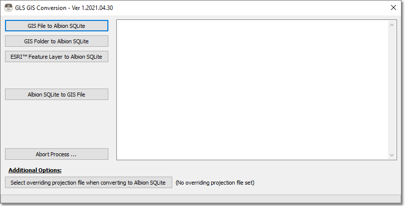
Import to SQLite
Select among importing an
•External File-based GIS data set: Supported are ESRI™ .SHP; External Spatialite .SQLite (and normal .SQLite); ESRI™ .MDB File Geodatabase; Google™ Earth .KML/KMZ, GeoJSON .GeoJSON and Microsoft™ Excel .XLS/XLSX files.
•External Folder-based GIS data set: Supported are ESRI™ version 9 and later Geodatabase .GDB Folders that do not use the Compressed Data Format (.CDF files in the .GDB Folder).
•Internet Online ESRI™ Feature Layer on an ESRI™ MapServer: Enter the public URL in the format proposed and dialog box provided. It is recommended to tick mark the 'Import first 100 records only' option the first time when testing the URL.
After you have selected the source data, you will be prompted for the location and name of the output SQLite file. The import progress will be shown in the window by updating the percentage completed value. Please be patient as this process can take a long time for large files.
Should you need to stop the import process for some reason, click on the 'Abort Process...' button. Wait a few seconds for the process to come to a complete halt.
Finally, Windows Explorer should open with the exported .SQLite file highlighted. This .SQLite file can then be dragged and dropped into the open Albion or GLS Application.
Additional Options:
Should you need to override (but not convert) the projection of the resulting .SQLite file, e.g. from a missing or incorrect projection to a valid projection, the 'Select overriding projection file when converting to Albion SQLite' button can be clicked, and the overriding standard .PRJ file can be selected.
Then repeat the process of importing to a .SQLite file.
Export from Albion SQLite
The 'Albion SQLite to GIS File' option first prompts you for the source Albion SQLite file and then for the destination file. The following destination formats, that can be selected from the ensuing 'Save as type' list box, are supported: Google™ Earth .KMZ, Spatialite SQLite .SQLite3 and GeoJSON .GeoJSON formats.
Spatialite is a special variant of the SQLite format, that is compatible with ESRI™. See the next section below for more details on how to import the Spatialite file into ArcGIS.
Note: Multiple GeoJSON files will be exported for each layer in the SQLite file.
Finally close the window by clicking on the top right cross icon.
How to convert an exported Spatialite SQlite file into an ESRI™ Geodatabase using ArcGIS™ Pro
The general procedure, for example in ESRI™ ArcGIS™ Pro, to import the Spatialite file is as follows:
•Create a new or load an existing Geodatabase (.gdb)
•Right-click on the new database as listed in the Catalog, and then select 'Import / Feature Class(es)...'
•Select the feature(s) to import from the Spatialite file (e.g. main.wa_pipe_data)
•Then click on the 'Run' button at the bottom right of the import pane
•Now add selected features from the new Geodatabase to an existing or new Map, to display the features.