GIS > Tools >Spatial, Geometry and Data Comparison (select from Main Menu)
Data comparison tool.
Allows the user to compare data sets to one another, mostly to see what data changed from one update to the next or to inspect current and future data changes (such as e.g. land use changes as shown in the screen-shot below).
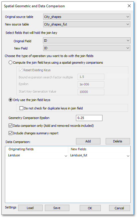
•Select from the Original source table drop-down list the original source table for the comparison.
•Select from the New source table drop-down list the new source table, i.e. the new source table will be compared with the original source table.
•From the Original Field drop-down list, select the join key of the original source table.
•From the New Field drop-down list, select the join key of the new source table, i.e. matching field values between the new and original fields will establish the join. Note, the two field names (i.e. ID in the above example) do not have to be the same.
•For data comparison only (i.e. to switch of the geometry comparison option, as demonstrated in the above example), select the Only use the join field keys toggle. Then tick the Data comparison only tick box.
•Specify which fields to be compared in the Data Comparison frame by applying the Add button and selecting the fields from the ensuing drop-down lists. In the above example, the Land_use field values will be compared with the Landuse_fut field values.
•Tick the Include changes summary report tick box (and click OK) to obtain a summary table of all the changes as shown in the screen-shot below.
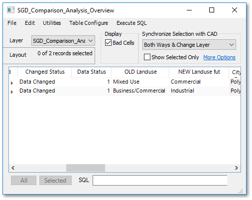
•Notice, there is a Changed Status field indicating that their were data changes detected. The OLD Landuse and NEW Landuse_fut fields will list side-by-side the changes in land use.
• Note, a spatial geometric comparison can also be performed on the data by selecting the Compute the join field keys using a spatial geometry comparison toggle. Hereby the geometry of objects (i.e. similar geometric shapes) will be used to establish a join instead of a database field key.