GIS > Tools >Snap Points To Lines (select from Main Menu)
Snap points geometry to nearest line and record angle of line.
This tool finds CAD or GIS lines that are close to GIS points, and inserts the angle of the line into a field in the point database. Points can also be snapped to the matching line. The function opens the Pickup Point Rotation box, in which the following can be set:
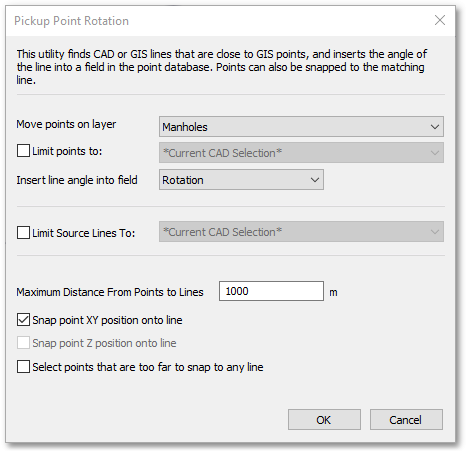
•Move points on layer: Choose the point layer from the drop-down list. In the above example, the GIS layer Manhole was selected.
•Limit points to: A tick box to limit the points to the current cad selection only – unticked means all records of layer considered.
•Insert line angle into field: Select the field from the drop-down list to insert the angle of the line the point snaps to – this is mandatory, which means that a field (of type Real) must be selected for the function to work. In the above example, the field Rotation was selected.
•Limit Source Lines to: A tick box to limit the lines considered – unticked means all line entities are considered.
•Maximum Distance From Points to Lines: Points further away from a line than this tolerance value, will be excluded from the snap operation. See last bullet, where these points can be selected for inspection.
•Snap point XY onto line: Tick box to snap the point (XY position) to the closest line within tolerance. If unticked, this will only insert the line angle value, without moving the point entity.
•Snap point Z position onto line: Tick box to snap the point (Z position) to the closest line within tolerance.
•Select points that are too far to snap to any line: Tick box to select points that were not within the tolerance set – user can manually investigate.