GIS > Tools >Spatial Correlation (select from Main Menu)
Import text into a GIS layer via spatial correlation.
This function imports text into a GIS layer. Note, the following symbols are used to describe the importing process: (A) represents the Import From Layer and (B) represents the Import Into Layer. Furthermore, there are two modes available for importing text into the GIS layer, viz. from another GIS layer or from a CAD layer. The Spatial Text Correlation input box will adapt accordingly, enabling only the tick boxes and drop-down lists relevant to the chosen import mode.
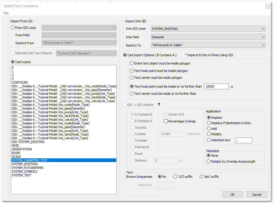
• Within the Import From (A) frame:
oChoose the import mode, i.e. toggle either From GIS Layers or CAD Layers.
oIf import mode: From GIS Layers:
▪Select from the From GIS Layer drop-down list the GIS layer to import from.
▪Select from the From Field drop-down list the database field to import from.
▪The Restrict From drop-down list can be set to specify the import restriction (i.e. to import only from the restricted records). The default option is to allow *All Records In Table*
oIf import mode: CAD Layers:
▪From the CAD layers list, select the CAD layer containing the text to import (as shown in the above example, viz. SYSTEM_DIAMETER_TEXT)
•Within the Import Into (B) frame:
oSelect from the Into GIS Layer drop-down list the GIS layer to import into.
oSelect from the Into Field drop-down list the database field to import into.
oThe Restrict To drop-down list can be set to restrict the output (i.e. fill only the restricted output records). The default option is to fill *All Records In Table*
oThe following CAD Import Options are available (i.e. enabled if the from CAD Layers import mode was chosen):
▪Entire text object must be inside polygon
▪Text hook point must be inside polygon
▪Text center must be inside polygon
▪Text hook point must be inside or no further than xxxx m: Note, this option can be used to import from text objects into GIS Layers containing either polygons, lines or points.
▪Text center must be inside or no further than xxxx m. Note, this option can be used to import from text objects into GIS Layers containing either polygons, lines or points.
oThe following GIS - > GIS Options are available (i.e. enabled if the From GIS Layers import mode was chosen). The description below is also available from within the program by clicking on the ![]() button:
button:
▪A Contains B: The bounds of B fall entirely within the bounds of A.
•Center of B: Only the center of B falls within the bounds of A.
•Percentage Overlap: Calculates within which polygon from A, the largest percentage of the area of polygon B resides. Tolerance is entered in % for this function, and where there is only a single polygon from A with overlap then more than the tolerance value of B should be inside A to be considered.
▪B Contains A: The bounds of A fall entirely within the bounds of B.
•Center of A: Only the center of A falls within the bounds of B.
▪Touches: Only the border of the two polygons are touching/snapped. No point from either polygon may fall within the bounds of the other.
▪Crosses: Polylines crossing each other are considered if the overlapping length falls within the specified tolerance value.
▪Overlaps: Polygons overlapping each other are considered if the overlapping edge length falls within the specified tolerance value.
▪Intersects: A combination of all of the above.
▪Equal: The two polygons must be an exact replica of each other with regard to size and position.
▪Distance: the two polygons must fall within a certain range/distance of each other.